Posts

Showing posts from 2012

Our natural capital

Image
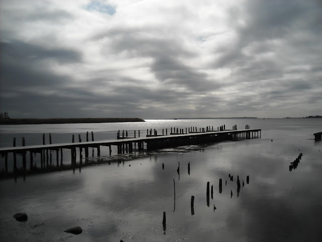
When people travel to Washington, DC, one of the first things they will likely do is visit the museums, monuments, and restaurant-filled neighborhoods.   As a naturalist, my first instinct is to visit the parks and natural areas in any region I travel to.  Yet why would I try and go on a safari in the middle of Washington, DC? Perhaps it may be surprising to know that our capital has a lot of natural capitol.   Natural capitol  is any sort of natural resources that has some positive value.  For example, wetlands are usually abundant in natural capitol because the provide us with water filtration, are biologically diverse, act as a flood control mechanism, and they provide us with a source of recreation.  In Washington, DC, tidal wetlands with fresh water along the Potomac River provide a refuge for a diverse array of wildlife in a densely urban area (see photo A).  The Washington metro area is dotted with parks, trails, greenways (photo B), and freeway berms are often planted with a

Envisioning a climate-change ready and ecofriendly waterside vacation home complex

Image
The following map shows my vision for what a vacation  town-home  complex in Norfolk, Virginia could look like.  Norfolk lies within the lower watershed of the Chesapeake Bay , America's largest  estuary.  Home to vast marine resources- and a vast human population, people who settle in this region should do everything they can to  minimize  impacts to this  sensitive  coastal ecosystem.    Some of the content in this map will no doubt be  controversial.   But we must be willing to make changes such as those presented in this map if we are to live  sustainability  - and happily - in a low elevation coastline.   Please note:  this map is not meant to be an engineering plan for this site.  It is merely a visual concept model of what would take place here.   Please click on map to enlarge.  

Find me on Linkedin!

Image
Are you a prospective employer in the environmental conservation field?  Then please follow me on my new LinkedIn Page: www.linkedin.com/pub/alex-palmer/5b/913/74b/

Keeping connected: My reflections on the NAI National Workshop

Image
This blog post is a draft of an article of the Mid-Atlantic region newsletter  of the National Association for Interpretation .  The opinions and commentary, though, are my own.   The other day I went for a hike at First Landing State Park in Virginia Beach, Virginia.  The weather was oddly warm for early December, and I regrettably had to carry my coat and sweater during my afternoon excursion.  Even the skinks (small lizards) were perplexed, with many of them cautiously peeking their heads up from underneath the leaf litter of a maturing maritime forest.  A metallic sounding wind rushed through the barren sweetgum trees, though, sending fourth a reminder that winter will indeed be back soon. I stopped and examined some swamp bay bushes growing along the trail, and I remember learning about them on my field trip during the recent NAI National Workshop.  The swamp bay ( Persea palustris ) is a small evergreen tree in the laurel family native to the Southeast, and its fragrant leave

Naturally Homesick

Image
The other week I went for a hike at Prince William Forest Park, which consists of over 15,000 acres of forested trails, streams, and hills a short commute south from Washington, DC.  The park preserves one of the largest remaining tracts of Piedmont forest, which once extended almost continuously from New York to Georgia.  All 37 miles of hiking trails in the park are surrounded by this glorious forest, and some of the trails tread a long flowing brooks and streams with small waterfalls and cascades. The sound of leaves crunching underneath my feet, and that sweet smell of autumn aroused a sensation that had more to do then with being just "out in the woods."  It felt like home. As much as I love the coastal environment where I am living now (the tidewater region of Virginia), I frequently miss those foot hills near the Appalachians.  I miss seeing salamanders hiding under rocks in a cool, spring-fed stream.  I miss being surrounded by nearly endless forest, with tall nor

Coming Winter/Spring 2013: My Linkedin Page

For readers of my blog who are seeking qualified environmental educators, natural history interpreters, Geospatial analysts, GIS technicians, or GPS field technicians, stay tuned for my upcoming Linked page.   For now, please see my resume page of this blog site.   

It's a privet thing, okay? Controlling invasive privet at Hoffler Creek Wildlife Preserve

Image
Situated far back into the quiet and dull suburban subdivisions of Portsmouth, Virginia is a somewhat unexpected place; it is a place that easily breaks the monotony of neatly trimmed lawns and dated cookie-cutter houses.  The Hoffler Creek Wildlife Preserve protects one of the last remaining undeveloped tracts of land in the Portsmouth city limits (see map below).  This protects the water quality of the Hoffler Creek tidal estuary (see Photo A), and the land-areas of the preserve are filled with lush Mid-Atlantic maritime forest (Photo B). View Larger Map Photo A: The Hoffler Creek tidal estuary Photo B:  A milder climate and a lack of urban development has helped preserve the maritime forest community at Hoffler Creek Wildlife Preserve. In the middle of the wildlife preserve is a natural-looking, mostly freshwater lake (Photo C).  Prior to the establishment of the wildlife preserve, the land was a sand and gravel pit that was quarried to provide a foundation for

There's beauty in a native berry

Image
American Beautyberry ( Callicarpa americana ) is a wild growing shrub native to the southeastern United States.  Native plants provide an important food source for wildlife, and can also be attractive as landscaping plants.  Photo by Robert Palmer.  

Paradise or Hell? How tourism development can be both stupid and wonderful

Image
Environmentalists can be such pessimists.  They can (and often are) sheer "Debbie-downers" in their outlook on life and the environment - sometimes to the point of excess.  I can name more than a dozen moments within the last few months where I have been with a friend or family member out on a park or trail, where even at the happiest moments of our outdoor adventure I decide to bluntly bring up the problem of invasive species within the park, or how surrounding development is impacting bird populations, or how large predators have been eliminated from the region and how budget cuts may necessitate the closure of the park and how- well need I say more? I ran into this problem with myself again when I took some friends from out-of-town to the Outer Banks of North Carolina (see map below). The Outer Banks are a long, nearly continuous stretch of barrier islands composed of sand that run the length of North Carolina's coastline on the Atlantic Ocean. View Larger Map

Sand and Steel: My Summer Educating Urban Youth

Image
The opinions and commentary expressed in this blog post are my own, and therefore they do not necessarily represent the views and policies of the National Park Service, the Dunes Learning Center, or any affiliated organizations.   This past summer I worked as a naturalist with the Dunes Learning Center , a non-for-profit residential environmental education center and camp located within the Indiana Dunes National Lakeshore .  The camp and park are located in close proximity to the urban sprawl of Chicago and surrounding suburbs, where rapid development, high-impact industry, and economic decay have ravaged the region.  In between these blighted areas, however, are small pockets of gems.  Adjacent to rusty steel mills and putrid landfills are white sandy beaches, tall and wavy sand dunes, and a diverse array of colorful wildflowers (see Photos A and B and C) Photo A:  Butterfly weed and black-eyed susans in bloom in an oak-savanna woodland along the Inland Marsh Trail in the Indi

Notes: The Trouble with Thypha (Cattail)

Image
Introduction The following are some of my notes from a lecture I attended at the headquarters to a national park in Indiana on wetland restoration and cattail invasion.   Wetlands  are any area of land that is soaked with water for most of the year (but is not just open water such as in a lake).  Normally, wetlands have a diverse array of aquatic plants  such as various grasses, sedges, waterlilies, etc.  Within the last few centuries, however, many wetlands - both natural and man-made - are quickly giving way to a monoculture of cattail ( Thypha spp. ), a reed that frequently grows in shallow water (see Figure 1).  This lecture I attended discusses how and why cattail has become an invasive species, what people can do to monitor the situation, and how to control the invasion of cattail reeds. Figure 1:  Cattail reeds in a marsh.  Photo by Joy Marburger Cattail considered invasive since the 1950s. Cattail is in the Family Typhacea and its only genus is  Typha. Has wind-dis

Parks RX: Parks and Trails for your Health and Sanity

Image
I remember traveling though an airport in Salt Lake City, UT and hearing the loudspeaker play a pre-recorded announcement reminding travelers not to smoke in the terminals, and that this rule was a apart of Utah's "indoor clean air" act. Cigarette smoke aside, I could not help but ponder the quality of indoor air in any public facility - including school classrooms, restaurants, and health clubs.  It almost seemed to me that indoor air quality was worse than outdoor air quality, including the air in urban and industrialized areas. Could the fact that our society spends large amounts of time indoors be a contributing factor for poor health?   Certainly our sedentary lifestyles are a culprit.  We sit inside and and watch TV, drive our cars to nearby places, hire carpenters to lift heavy household objects, other things to mitigate our need to perform physical labor.  Of course, this immobile lifestyle combined with a diet of low quality, high-fat foods contributes to a s

Great Marsh Trail

Image
Itchy feet would have been a good way to describe how I was feeling a few days ago.  It was the end of a much needed weekend, and there was still a few hours of daylight left.  I looked at a map of the park to see if I could locate a trail I had not yet been on.  Rather inconspicuous in the corner of my wrinkled fold-out map was a small loop trail called the "Great Marsh Trail."  It was a trail that the park had built a few years ago to provide public access to a recently restored wetland complex I pulled into a gravel parking lot.  At then end of the lot was a modest brown sign that just said "trail" with an arrow pointing off into a mowed grassy walkway. The sun was shining through the trees and I could hear red-eyed vireos ( Vireo olivaceus ) and eastern towhees ( Piplio  erythrophthalmus )   singing their springtime calls with a hint of summer lethargy.  Warblers of all colors and shapes scurried around in the brush, and brightly colored red-headed woodpe

What are they DUNE-ing here?

Image
The other day I went hiking on a trail that I had not visited before in the Indiana Dunes National Lakeshore. View Larger Map They call it the Inland Marsh Trail, which is a series of sand dunes (mounds of wind-driven sand) that had formed about 10,000 years ago and then grew over with vegetation.  In some of the blowouts and other areas where sand had been eroded away, marshes and wetlands had formed that were isolated from nearby Lake Michigan, hence the name 'Inland Marsh.' As I was meandering along the trail taking pictures of all of the unique plants and wildlife fluttering around me, I ran into a young couple who were just off the trail gazing at the ground rather dumbfounded.  The gentlemen asked me, "Excuse me, but have you seen lizards  around here?"  "Yeah, well we have a couple different species of lizards around here," I responded with an as-a-matter-of-fact reply.  I then caught myself and realized these people were nothing short of mesm