Natural Notes: Chicago Wilderness Congress 2016
This blog post consists of my notes from the Chicago Wilderness Congress gathering at the University of Illinois Chicago Forum, held on November 2, 2016 in Chicago, Illinois.
Lecture 1: Restoring the Wetlands of Calumet
Nat Miller, Chip O'Leary, and Gary Sullivan.
The former area of glacial "Lake Chicago" are now lowlands that make up the Calumet Region. This flat and sandy area of land is dotted with various lakes and marshes and has numerous creeks and rivers passing through it. In some areas, dune and swale topography is present. Historically, the Calumet Region was very open with scatterings of oak trees along with scattered pockets of marsh. There were 16 species of reptiles and amphibians, and large marshes provided habitat for marsh birds and wetland passerines.
The Calumet Region has undergone many changes within the last 200 years. There is been a lot of habitat fragmentation, although most of the original plant communities are "hanging in there." Birds, however, are not fairing as well, especially since 1980 where many breeding bird populations began to drop off (although until 1980 most of the original breeding bird species were still present).
The most likely cause for the decline in breeding birds in marshes in the Calumet Region is likely due to the unprecedented loss of marsh habitat. At present, only 4,000 acres of the original 20,000 acres of marsh habitat in the Calumet Region remain, with most of it in a degraded condition. And since 1/3 of all bird species in North America are in need of urgent conservation action, marsh restoration for birds in the Calumet Region is a top priority.
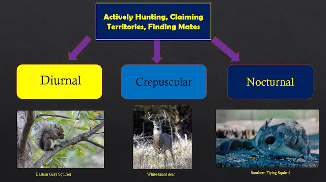
From 2015 to 2016, a breeding bird survey was conducted in various marshes across the Calumet Region. Species presence and territory was assessed using bird call surveys. This data was then compared to overall marsh habitat quality.
Marsh habitat quality is assessed based upon the following habitat structure index:
1 = vegetation monoculture
3 = Balance of vegetation and open water
5 = Open water
The ratio of open water to vegetation is assessed by analysis of aerial imagery. Bird species loss correlates with the decline of wetlands with level 3 characteristics. In other words, an ideal wetland habitat structure would be a balance of vegetation and open water (see figure 1). Other qualitative factors include species composition and the amount of edge habitat.
Lecture 2: Restoring Hemimarsh habitat in the Calumet Region
Nat Miller, Chip O'Leary, and Gary Sullivan.
Historically, about 20,000 acres of marsh were present in the Calumet Region. The small percentage that remains is in a degraded condition. Historically, marshes with interconnected pockets of open water (hemimarshes) were maintained by muskrats, who would eat their way through tall marsh vegetation, allowing deeper areas of water to remain clear of reeds and other aquatic emergent vegetation. The loss of this habitat structure, along with pollution and invasive species such as common carp (Cyprinus carpio) which eat submerged vegetation.
So what are some solutions to address the decline of hemimarshes in the Calumet Region? Some control methods currently being implemented include hydrological control, carp management, and invasive species management. The ideal result is a hemimarsh with balanced interspersion of open water with submerged plants and areas with emergent vegetation. In the Calumet Region, Hegewisch Marsh is showing good hemimarsh development following recent restoration work.
Lecture 3: Oak Ecosystem Recovery Plan
Drew Hart (US Forest Service), Jim Anderson (Lake County Forest Preserves), Matt Evans (Chicago Wilderness), Paul Labovitz (Indiana Dunes National Lakeshore)
Completed in 2013, the plan for oak ecosystem restoration in the Chicago Wilderness (CW) region can be viewed on the Chicago Wilderness Website:
www.chicagowilderness.org
The goals for oak ecosystem restoration in the CW region for 2016-17 are to map the current distribution of oak ecosystems in Southeast Wisconsin, Northwest Indiana, and extreme Southwest Michigan. This will be used for an oak ecosystem quality assessment. Northeast Illinois is already mapped with three data layers: (1) 1830s land survey records, (2) 1930s aerial photography, and present-day satellite imagery. The goal is to create digital polygon layers for each of these time periods for the entire CW region which can be analyzed and mapped in a geographic information system (GIS). Analysis of spatial data for Illinois have revealed that 17% of original oak ecosystems remain. Pre-settlement mapping of the distribution of oak ecosystems for the entire CW region is expected to be completed by June of 2017.
The quality assessment will take into account several factors, and the preliminary criteria (currently in draft stage) includes:
Lecture 1: Restoring the Wetlands of Calumet
Nat Miller, Chip O'Leary, and Gary Sullivan.
The former area of glacial "Lake Chicago" are now lowlands that make up the Calumet Region. This flat and sandy area of land is dotted with various lakes and marshes and has numerous creeks and rivers passing through it. In some areas, dune and swale topography is present. Historically, the Calumet Region was very open with scatterings of oak trees along with scattered pockets of marsh. There were 16 species of reptiles and amphibians, and large marshes provided habitat for marsh birds and wetland passerines.
The Calumet Region has undergone many changes within the last 200 years. There is been a lot of habitat fragmentation, although most of the original plant communities are "hanging in there." Birds, however, are not fairing as well, especially since 1980 where many breeding bird populations began to drop off (although until 1980 most of the original breeding bird species were still present).
The most likely cause for the decline in breeding birds in marshes in the Calumet Region is likely due to the unprecedented loss of marsh habitat. At present, only 4,000 acres of the original 20,000 acres of marsh habitat in the Calumet Region remain, with most of it in a degraded condition. And since 1/3 of all bird species in North America are in need of urgent conservation action, marsh restoration for birds in the Calumet Region is a top priority.
From 2015 to 2016, a breeding bird survey was conducted in various marshes across the Calumet Region. Species presence and territory was assessed using bird call surveys. This data was then compared to overall marsh habitat quality.
 |
| Figure 1: An ideal marsh habitat structure would consist of a relatively equal proportion of vegetated areas and open water. |
Marsh habitat quality is assessed based upon the following habitat structure index:
1 = vegetation monoculture
3 = Balance of vegetation and open water
5 = Open water
The ratio of open water to vegetation is assessed by analysis of aerial imagery. Bird species loss correlates with the decline of wetlands with level 3 characteristics. In other words, an ideal wetland habitat structure would be a balance of vegetation and open water (see figure 1). Other qualitative factors include species composition and the amount of edge habitat.
Lecture 2: Restoring Hemimarsh habitat in the Calumet Region
Nat Miller, Chip O'Leary, and Gary Sullivan.
So what are some solutions to address the decline of hemimarshes in the Calumet Region? Some control methods currently being implemented include hydrological control, carp management, and invasive species management. The ideal result is a hemimarsh with balanced interspersion of open water with submerged plants and areas with emergent vegetation. In the Calumet Region, Hegewisch Marsh is showing good hemimarsh development following recent restoration work.
Lecture 3: Oak Ecosystem Recovery Plan
Drew Hart (US Forest Service), Jim Anderson (Lake County Forest Preserves), Matt Evans (Chicago Wilderness), Paul Labovitz (Indiana Dunes National Lakeshore)
Completed in 2013, the plan for oak ecosystem restoration in the Chicago Wilderness (CW) region can be viewed on the Chicago Wilderness Website:
www.chicagowilderness.org
The goals for oak ecosystem restoration in the CW region for 2016-17 are to map the current distribution of oak ecosystems in Southeast Wisconsin, Northwest Indiana, and extreme Southwest Michigan. This will be used for an oak ecosystem quality assessment. Northeast Illinois is already mapped with three data layers: (1) 1830s land survey records, (2) 1930s aerial photography, and present-day satellite imagery. The goal is to create digital polygon layers for each of these time periods for the entire CW region which can be analyzed and mapped in a geographic information system (GIS). Analysis of spatial data for Illinois have revealed that 17% of original oak ecosystems remain. Pre-settlement mapping of the distribution of oak ecosystems for the entire CW region is expected to be completed by June of 2017.
The quality assessment will take into account several factors, and the preliminary criteria (currently in draft stage) includes:
- The size of remaining blocks of oak ecosystem lands
- The percentage of fragmentation
- Soil types
- Proximity to other natural areas
- Percent canopy cover
- Number of oak saplings versus mature trees
- Oak species presence
- Native shrubs present
- Average floristic quality index (FQI)
- Number of bird species
- Number of amphibian species

Comments
Post a Comment